Short note: This website is in Beta - we are currently building everything up but you can already find the apps to download and participate! Thank you and stay safe!
Information: HydroCrowd
This depends on the type of station you want to report from: a weather station, a water station, the Weather@Home or the Photo Note. Look at the instructions for every station type below:
1.) Are you at a weather station?
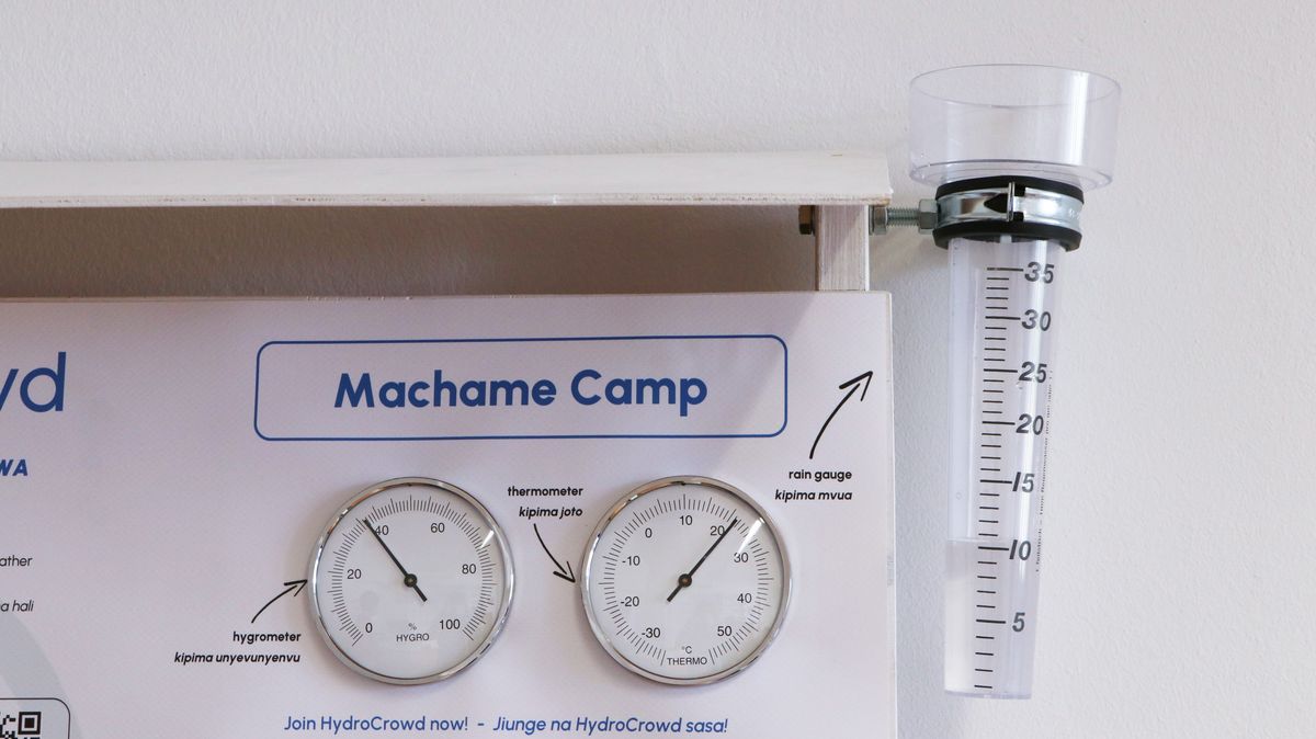
Take a photo of the info board. Make sure that it is possible to read the values on the thermometer, hygrometer and the rain gauge from the photo (see example below).
2.) Are you at a water station?
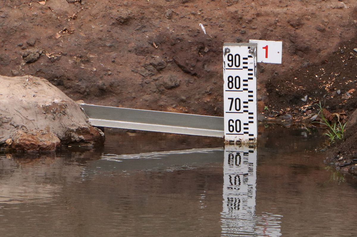
Take a photo of the water level gauge in the water (see example below) and make sure that it is possible to read the value of the water level gauge from the photo. Note that the water level gauge at your station could look slightly different than in the example.
3.) Do you want to report from your Weather@Home station?
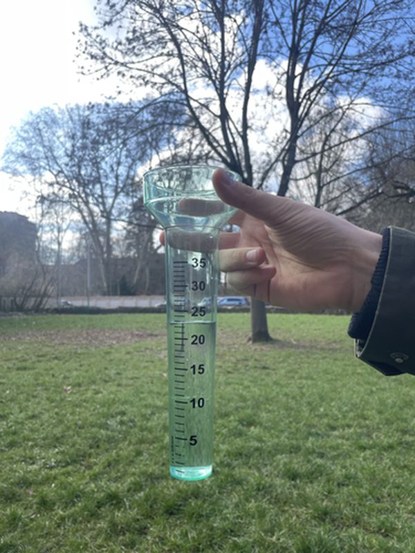
Take a photo of your rain gauge (see example below) and make sure that it is possible to read the value easily.
4.) Do you want to report a photo note?
These can be used to share photos of any kind of weather events, for example a hail storm, a flooding or a dry river bed. Here are some examples:
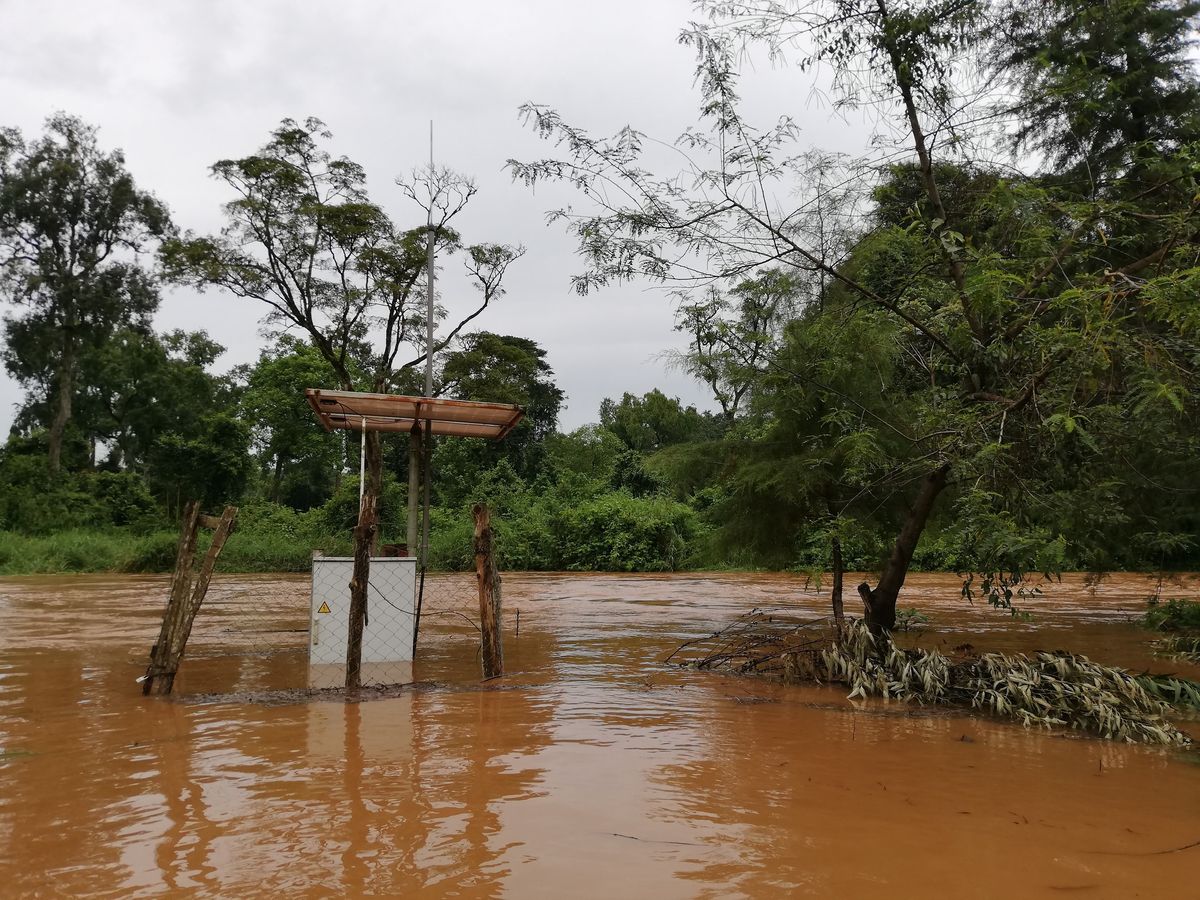
On the picture above you can see a flooded river.
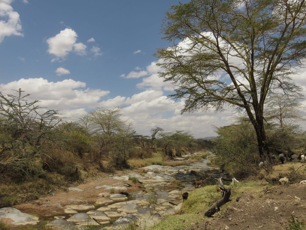
On the picture above you can see a nearly dried out river.
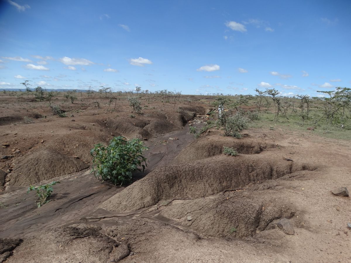
On the picture above you can see heavy soil erosion (the rain has partially washed away the soil).
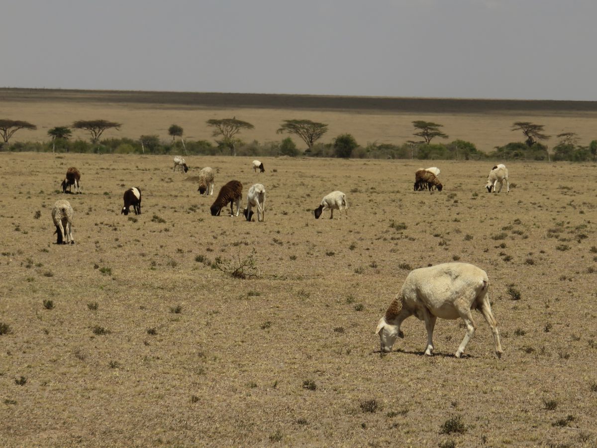
On the picture above you can see a drought.
Hii inategemea aina ya kituo unachotaka kuripoti: kituo cha hali ya hewa, kituo cha maji, Hali ya Hewa@Nyumbani au Dokezo Picha.
Tazama maagizo ya kila aina ya kituo hapa chini:
1.) Je, uko kwenye kituo cha hali ya hewa?
Je, uko kwenye kituo cha hali ya hewa? Piga picha ya ubao wa taarifa. Hakikisha kwamba inawezekana kusoma namba kwenye kipima joto, kipima unyevunyevu na kipima mvua kutoka kwenye picha (angalia mfano hapa chini).

2.) Je, uko kwenye kituo cha maji?
Piga picha ya kipima(rula) kiwango cha maji kwenye maji (tazama mfano hapa chini) na uhakikishe kuwa inawezekana kusoma namba za kiwango cha maji kutoka kwenye picha. Kumbuka kwamba kipimo cha kiwango cha maji kwenye kituo chako kinaweza kuonekana tofauti kidogo kuliko katika mfano.

3.) Je, ungependa kuripoti kutoka kwa kituo chako cha Hali ya Hewa@Nyumbani?
Piga picha ya kipimo chako cha mvua (tazama mfano hapa chini) na uhakikishe kuwa inawezekana kusoma thamani za namba kwa urahisi.

4.) Je, ungependa kuripoti dokezo picha?
Hizi zinaweza kutumika kushirikisha picha za aina yoyote ya matukio ya hali ya hewa, kwa mfano dhoruba ya mvua ya mawe, mafuriko au mto mkavu. Hapa kuna baadhi ya mifano:

Kwenye picha hapo juu unaweza kuona mto uliofurika.

Kwenye picha hapo juu unaweza kuona mto unakaribia kukauka.

Kwenye picha hapo juu unaweza kuona mmomonyoko mkubwa wa udongo (mvua imeondoa sehemu ya udongo).

Kwenye picha hapo juu unaweza kuona ukame.
Esto depende del tipo de estación de la cual desea informar: Estación Meteorológica, Estación Hidrológica, Tiempo en Casa o Foto Nota. Mire a continuación las instrucciones para cada tipo de estación:
1.) ¿Está en una estación meteorológica?
Saque una foto del panel informativo. Asegúrese de que es posible leer los valores del termómetro, higrómetro y pluviómetro en la foto (ver ejemplo más abajo)

2.) ¿Se encuentra en una estación hidrológica?
Saque una foto del indicador del nivel de agua en el agua (ver ejemplo más abajo) y asegúrese de que es posible leer el valor del indicador del nivel de agua en la foto. Tenga en cuenta que el indicador del nivel de agua de la estación puede tener un aspecto ligeramente distinto al del ejemplo.

3.) ¿Desea informar desde su estación "Tiempo en Casa"?
- Saque una foto de su pluviómetro (ver ejemplo más abajo) y asegúrese de que es posible leer el valor fácilmente.

4.) ¿Desea informar con una Foto Nota?
Con ellas puede compartir fotos de cualquier tipo de fenómeno meteorológico, por ejemplo una tormenta de granizo, una inundación o el cauce seco de un río. Aquí tiene algunos ejemplos:

En la foto de arriba se puede ver un río inundado.

En la foto de arriba se ve un río casi seco.

En la foto de arriba puede ver el suelo considerablemente erosionado (la lluvia a lavado parcialmente el suelo)

En la foto de arriba puede ver un evento de sequía.
Turbidity can be measured with a turbidity tube (see image below).

The tube has a scale on the side. Higher values indicate that more particles are dissolved in the water and that it its less clear. In terms of water quality, the lower the value the better.
To measure the turbidity several steps are necessary:
First fill the bucket attached to the chain with water from the river. Try to collect water from the surface of the river and not from the river bed.
Then pour a little bit of water into the turbidity tube until it reaches the first mark (see sample photo below).
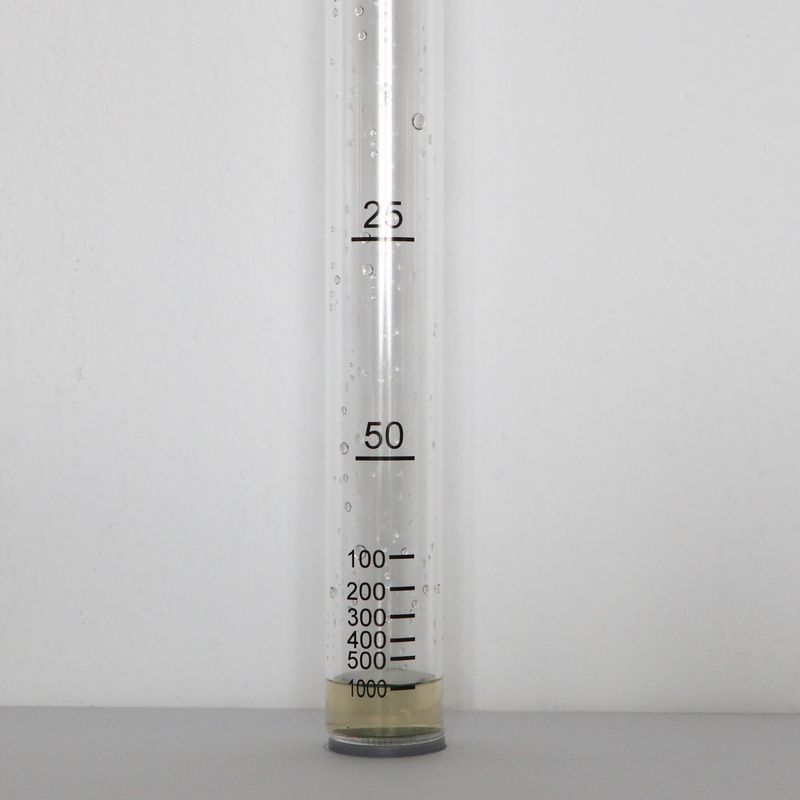
Now look into the turbidity tube from the top. Can you see the green circle at the bottom of the tube?
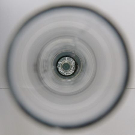
-If you can't see the green circle anymore, read the value at the lowest mark on the tube and enter the value in the appropriate field in the HydroCrowd app. If the green circle is still visible, fill the tube until the next mark. Repeat the process until you can't see the green circle anymore.
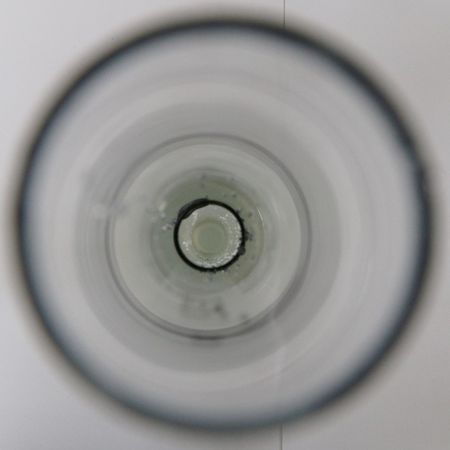
Enter the value in the application where the circle is no longer visible.
Topetope linaweza kupimwa kwa kutumia bomba la topetope (tazama picha hapa chini).

Bomba lina alama katika upande. Kiwango kikubwa kinaonyesha kuwa chembe nyingi zaidi huyeyushwa ndani ya maji na kwamba maji siyo meupe sana. Kwa upande wa ubora wa maji, kiwango cha chini ni bora zaidi.
Ili kupima topetope, hatua kadhaa zinahitajika:
Kwanza jaza maji kwenye jagi lililoshikiliwa na mnyororo kutoka mtoni. Jaribu kuchukua majiya juu ya uso wa mto na si kutoka kchin ya mto.
Kisha mimina maji kidogo kwenye bomba la topetope hadi ifikie alama ya kwanza (tazama mfano wa picha hapa chini).

Sasa angalia kwenye bomba la topetope kutoka juu. Je, unaweza kuona duara la kijani kibichi chini ya bomba?

-Ikiwa huwezi kuona mduara wa kijani tena, soma thamani katika alama ya chini kabisa kwenye bomba na uweke thamani hiyo katika sehemu inayofaa katika programu ya HydroCrowd. Ikiwa mduara wa kijani bado unaonekana, jaza bomba hadi alama inayofuata. Rudia mchakato hadi ambapo hutaweza kuona mduara wa kijani tena.

Ingiza thamani hiyo katika programu ambapo mduara haukuonekana tena.
La turbiedad puede medirse con un tubo de turbidez (ver la siguiente imagen).

El tubo tiene una escala en un lado. Los valores más altos indican que hay más partículas disueltas en el agua y que es menos clara. En términos de calidad del agua, cuanto menor sea el valor, mejor.
Para medir la turbiedad son necesarios varios pasos:
En primer lugar, se debe llenar con agua del río la jarra o el cubo fijado a la estación con. Intente recoger agua de la superficie del río y no del fondo.
A continuación, vierta un poco de agua en el tubo de turbidez hasta que alcance la primera marca (ver la foto de ejemplo abajo).

Ahora mire dentro del tubo de turbidez desde arriba. Puede ver el círculo verde en el fondo del tubo?

Si ya no puede ver el círculo verde, lea el valor en la marca más baja del tubo e introduzca el valor en el campo correspondiente de la aplicación HydroCrowd. Si el círculo verde sigue visible, llene el tubo hasta la siguiente marca. Repite el proceso hasta que ya no pueda ver más el círculo verde.

Introduzca el valor en la aplicación cuándo el círculo ya no sea visible.
A water level gauge can be used to measure the water level in a river. By taking regular measurements, you can record the changes in water level over time. The scale on the water level gauge is in centimeters (cm). This is one type of water level gauge, where each mark is 1 centimeter wide:
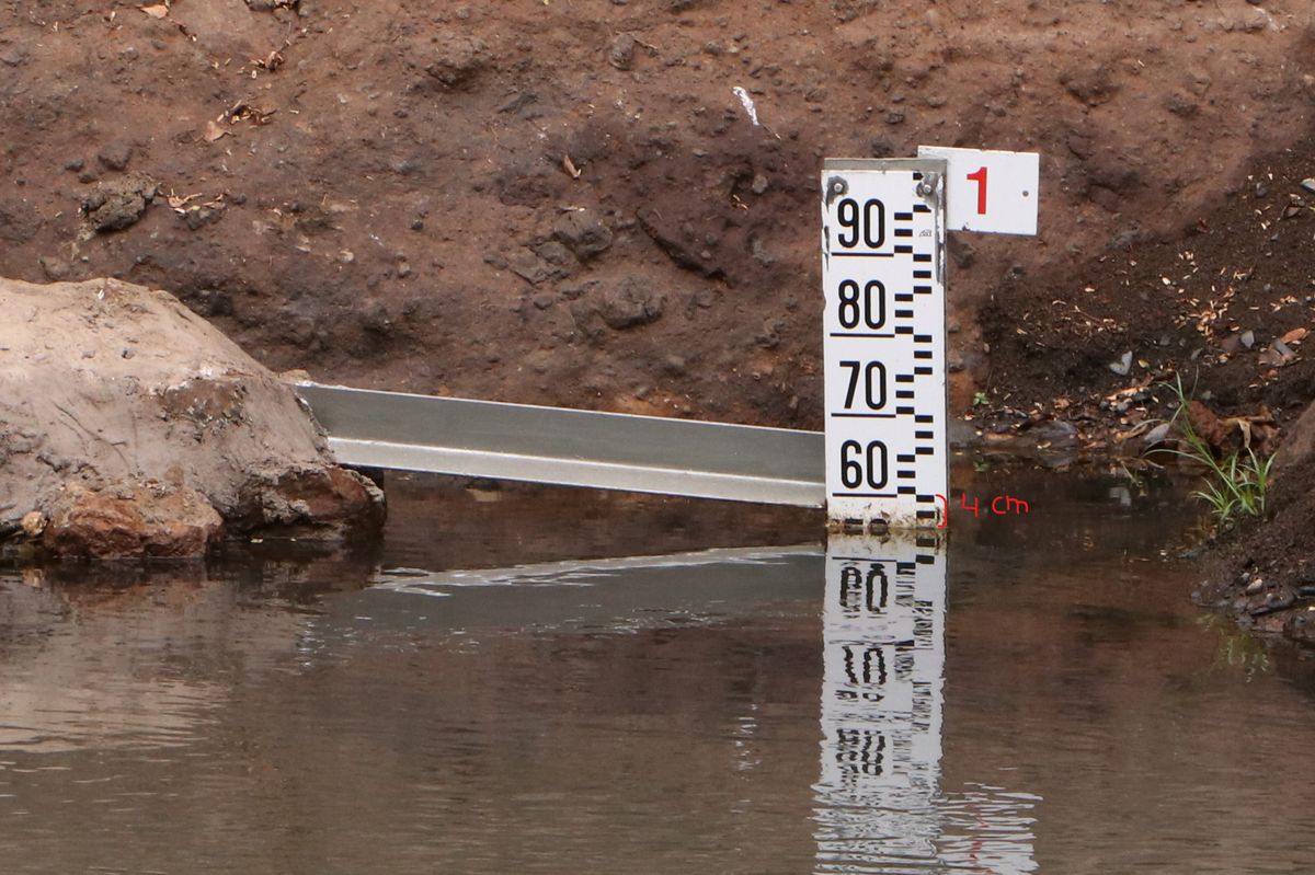
In this example, the water level is 56 cm (4 cm below 60). This is the value you enter as 'Water level value' in the app.
In the case that the water level of a river can rise above 1 meter (100 cm), several water level gauges will be mounted on top or diagonally above each other:
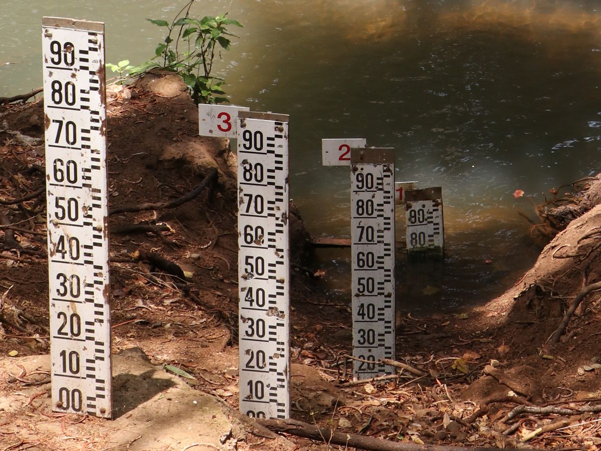
Then the number on top will tell you the maximum water level that can be measured at that particular gauge in meters. In the example above, it is 1 m. This is the value you enter as the 'Gauge number' in the app.
Kipimo cha kiwango cha maji kinaweza kutumika kupima kiasi cha maji katika mto. Kwa kuchukua vipimo vya kila mara, unaweza kurekodi mabadiliko katika kiwango cha maji kwa muda. Alama kwenye kipimo cha kiwango cha maji ni sentimita (cm). Hii ni aina moja ya kipima kiwango cha maji, ambapo kila alama ina upana wa sentimita 1:

Katika mfano huu, kiwango cha maji ni 56 cm (4 cm chini ya 60). Hiki ndicho kiasi unaweza kuweka kama 'Kiasi cha kiwango cha maji' kwenye programu.
Ikiwa kiwango cha maji cha mto kinaweza kuongezeka zaidi ya mita 1 (cm 100), Vipima kiwango cha maji kadhaa vitaonggezwa juu au kwa diagonally (kimbo) juu ya kila kimoja:

Kisha nambari iliyo juu itakuambia kiwango cha juu cha maji ambacho kinaweza kupimwa kwa kipimo hicho kwa mita. Katika mfano hapo juu, ni 1 m. Hii ndiyo thamani unayoweka kama 'Nambari ya kipimo' kwenye programu.
Un indicador de nivel de agua (regleta) puede utilizarse para medir el nivel del agua en un río o quebrada.
Realizando mediciones periódicas, se pueden registrar los cambios del nivel del agua a lo largo del tiempo. La escala del indicador del nivel del agua está en centímetros (cm). Este es un tipo de indicador del nivel del agua, en el que cada marca tiene 1 centímetro de ancho:

En este ejemplo, el nivel de agua es de 56 cm (4 cm debajo de 60). Este es el valor que debes ingresar en la aplicación como “Nivel de agua”.
En el caso de que el nivel del agua de un río pueda subir por encima de 1 metro (100 cm), serán montados varios medidores de nivel de agua uno encima del otro o en diagonal:

A continuación, el número de la parte superior te indicará en metros el nivel máximo de agua que puede medirse en ese indicador en concreto. En el ejemplo anterior, es 1 m. Este es el valor que introduces como "Número de regleta" en la aplicación.
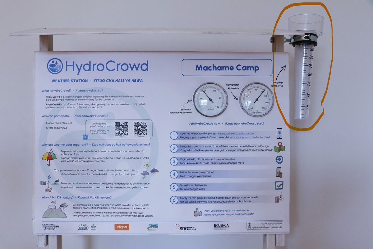
Mvua katika eneo fulani hupimwa kwa kipima mvua. Kwenye kituo, kipimo cha mvua kimewekwa upande wa kulia wa ubao wa taarifa (angalia mfano hapa chini).
Mvua hupimwa kwa milimita (mm). Alama zilizo kando ya kipimo cha mvua zinaonyesha ni kiasi gani cha mvua ilinyesha tangu mara ya mwisho kipima mvua kilipomwagwa. Kiwango kinagawanywa katika vipindi vya 1 mm (alama fupi) na 5 mm (alama ndefu). Kuangalia kiasi cha maji katika kipimo cha mvua. Simama mwenyewe, ili macho yako yawe kwenye urefu sawa na kiwango cha maji kwenye kipimo cha mvua (tazama mfano hapa chini).
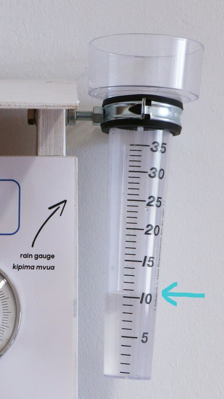
Alama iliyo karibu zaidi na kiwango cha maji katika kipimo cha mvua ni kiasi cha mvua. Katika mfano hapo juu mvua ni 10 mm. Baada ya kuwasilisha taarifa ya kipimo cha mvua, usisahau kumwaga maji katika kipimo cha mvua kwa kukigeuza juu chini na baadaye kukirudisha juu huku mdomo(inlet) ikielekea angani (kama ilivyo kwenye picha ya kwanza).
Rainfall at a certain location is measured with a rain gauge. At the station, the rain gauge is mounted on the right side of the info board (see example below).

Rainfall is measured in millimeters (mm). The scale on the side of the rain gauge indicates how much rain fell since the last time the rain gauge was emptied. The scale is divided into intervals of 1 mm (short marks) and 5 mm (long marks). Look at the water in the rain gauge. Position yourself, such that your eyes are at the same height as the water level in the rain gauge (see example below).

The mark closest to the water level in the rain gauge is the amount of rainfall. In the example above the rainfall is 10 mm. After submitting your rainfall measurement, don't forget to empty the rain gauge by turning it upside down and afterward turning it back with the inlet facing toward the sky (like it is in the first image).
¿Cómo medir la cantidad de lluvia?
La lluvia que cae en un lugar determinado se mide con un pluviómetro. En la estación, el pluviómetro está montado a la derecha del panel informativo ( ver ejemplo más abajo).

La lluvia o precipitación se mide en milímetros (mm). La escala situada en un lado del pluviómetro indica la cantidad de lluvia caída desde la última vez que se vació el pluviómetro. La escala está dividida en intervalos de 1 mm (marcas cortas) y 5 mm (marcas largas). Mire el agua del pluviómetro. Colóquese de manera que sus ojos estén a la misma altura que el nivel de agua del pluviómetro (ver ejemplo a continuación).

La marca más cercana al nivel del agua en el pluviómetro es la cantidad de lluvia. En el ejemplo anterior, la lluvia es de 10 mm. Después de enviar la medición de la lluvia, no olvide vaciar el pluviómetro volcándolo boca abajo y volviéndolo a poner boca arriba con la entrada mirando hacia el cielo (como en la primera imagen).
Kipimajoto hupima joto la hewa mahali fulani. Kipimajoto katika kituo hiki hupima joto kutoka -35 hadi 55 digrii Selsiasi (°C) (tazama mfano hapa chini).
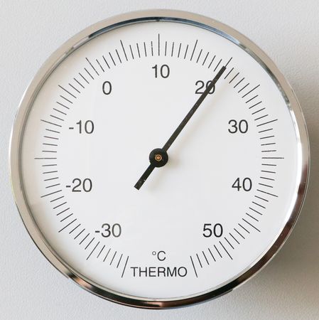
Wakati hali ya joto ni hasi (chini ya 0 °) ni kufungia. Kiwango kwenye thermometer imegawanywa katika vipindi vya 1 ° C (alama fupi) na 5 ° C (alama ndefu). Alama iliyo karibu na pointer ni halijoto ya sasa. Katika mfano juu ya joto ni 20 ° C.
The thermometer measures the air temperature at a certain location. The thermometer at this station measures temperatures from -35 to 55 degrees Celsius (°C) (see example below).

When the temperature is negative (below 0°) it is freezing. The scale on the thermometer is divided into intervals of 1°C (short marks) and 5°C (long marks). The mark closest to the pointer is the current temperature. In the example above the temperature is 20°C.
El termómetro mide la temperatura del aire en un lugar determinado. El termómetro de esta estación mide la temperatura entre -35 y 55 grados Celsius (°C) ( ver ejemplo a continuación).

Cuando la temperatura es negativa (por debajo de 0°) está helando. La escala del termómetro está dividida en intervalos de 1°C (marcas cortas) y 5°C (marcas largas). La marca más cercana a la aguja es la temperatura actual. En el ejemplo anterior, la temperatura es de 20 °C.
El higrómetro ( ver ejemplo más abajo) mide el grado de humedad del aire en un lugar determinado. También se denomina humedad relativa.
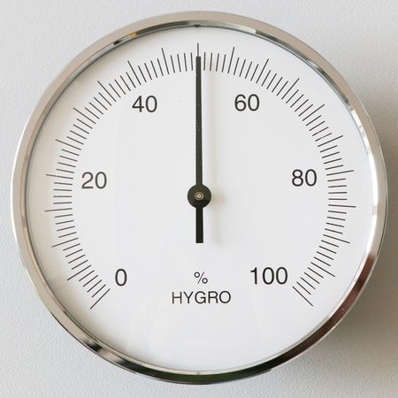
Puede medir la humedad desde el 0% (completamente seco) hasta el 100% (muy húmedo). La escala del higrómetro está dividida en intervalos del 1% (marcas cortas) y del 5% (marcas largas). La marca más cercana a la aguja es la humedad actual. En el ejemplo anterior, la humedad es de 50%.
Kipimo cha kupima unyevunyevu (tazama mfano hapa chini) hupima jinsi hewa ilivyo na unyevunyevu katika eneo fulani. Hii pia inaitwa unyevu wa kwa kulinganishwa.

Inaweza kupima unyevunyevu kwenye hewa kutoka 0% (kavu kabisa) hadi 100% (yenye unyevu sana). alama kwenye kipima unyevunyevu zimegawanywa katika vipindi vya 1% (alama fupi) na 5% (alama ndefu). Alama iliyo karibu na mshale ni unyevunyevu wa sasa. Katika mfano hapo juu unyevu ni 50%.
The hygrometer (see example below) measures how moist the air is at a certain location. This is also called relative humidity.

It can measure the humudity from 0 % (completly dry) to 100% (very humid). The scale on the hygrometer is divided into intervals of 1% (short marks) and 5% (long marks). The mark closest to the pointer is the current humidity. In the example above the humidity is 50%.
Unaweza kuchagua kati ya aina nne tofauti za vituo:
- Kituo cha hali ya hewa: Katika kituo hiki, unaweza kupima vipengele tofauti vya hali ya hewa kama vile mvua, halijoto na unyevunyevu. Hii inaweza tu kufanywa katika vituo vilivyopo vya HydroCrowd.
- Kituo cha maji: Katika kituo hiki, unaweza kupima kiwango cha maji na topetope kwenye maji ya mto. Hii inaweza tu kufanywa katika vituo vilivyopo vya HydroCrowd.
- Hali ya hewa @ Nyumbani: Unda kituo chako mwenyewe na utoe maelezo ya hali ya hewa kutoka kwenye kipimo cha mvua nyumbani kwako.
- Dokezo Picha: Pakia picha ya hali ya hewa au uchunguzi wa maji kutoka eneo lolote unalopenda.
You can choose between four different station types:
- Weather station: At this station, you can measure of different weather variables like rainfall, air temperature, humidity, and wind. This can only be done at existing HydroCrowd stations.
- Water station: At this station, you can measure the water level and turbidity of the river water. This can only be done at existing HydroCrowd stations.
- Weather@Home: Create your own spot and provide weather information from your rain gauge at home.
- Photo Note: Upload a photo of a weather or water observation from any location you like."
Puede elegir entre cuatro tipos de estación diferentes:
Estación meteorológica: En esta estación se pueden medir diferentes variables meteorológicas como precipitación, temperatura del aire y humedad. Esto sólo se puede hacer en las estaciones ya existentes de HydroCrowd.
Estación hidrológica: En esta estación se puede medir el nivel del agua y la turbiedad del agua del río. Esto sólo se puede hacer en las estaciones ya existentes de HydroCrowd.
Tiempo en Casa: Cree su propio punto y proporcione información meteorológica de su pluviómetro en casa.
Foto Nota: Suba una foto de una observación meteorológica o hidrológica desde el punto que desee.
Please visit the website about the SPOTTERON Platform on www.spotteron.net
This website uses no external trackers, no analytics, just session cookies and values your online privacy.

